 |
|
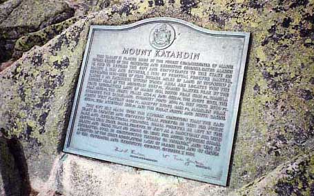
- Mount Katahdin
This tablet is placed here by the Forest Commissioner of Maine under order of the Governor and Executive Council dated March 16, 1932 to record the gift and conveyance to the state on March 3, 1931 and October 7, 1931 by Percival Proctor Baxter, Governor 1921-1925, of nine square miles
- of land in Township 3 Range 8 Mt. Katahdin, within which area are located this, the highest peak of the mountain,
- 5267 ft., named Baxter Peak by the state legislature laws
- of Maine 1931, South Peak 5240 ft., Pamola Peak, 4902 ft., the North Peaks 4734 ft., and 4612 ft., the Knife Edge, the North West Plateau, 4401 ft., Harvey Ridge, 4182 ft.,
- Hamlen Peak, 4751 ft., Rum Mountain 3361 ft. and the
- Great North and South Basins.
This gift was made upon the express condition that the
- said tract so donated and conveyed “shall forever be used for public park and recreational purposes, shall forever be left in the natural wild state, shall forever be kept as a sanctuary for wild beasts and birds, that no roads or ways for motor vehicles shall hereafter ever be constructed therein or thereon,” and was so accepted by the state legislature laws of Maine 1931 and by order of the Governor and Executive Council October 7, 1931.
Signed: Neil L. Violetti, Forest Commisioner
William Tudor Gardiner, Governor
|
